‘Champion of England’

The General Register Office doesn’t usually provide humour, but the 1861 census shows a recorder finding the bare-knuckle prize-fighter Tom Sayers at 10 Belle Vue Cottages (later renumbered 51 Camden Street). He wrote, with nationalist delight, Sayers’ occupation as ‘Pugilist – Champion of England’.

Sayers had come in the 1840s to Camden Town to learn and practise the trade of bricklayer with his brother-in-law, but quickly took up fighting for money. The 1851 census gives his address, with his then common-law wife Sarah and baby Sarah, nearby at 45 Bayham Street.  In the spring of 1860, Sayers became a national celebrity when he held the American champion John C Heenan – who was taller, heavier and younger than Sayer – to a draw in their 42nd round.  Sayers’ Wikipedia page has a delightful, if dubious, scrawled ‘Chalang’:

Camden Town was not the place for professional fights, which were usually held out-of-town to escape police attention. In Pierce Egan’s early history Boxiana or Sketches of Modern Pugilism (1829), only Tom Shelton is recorded fighting in Camden Town itself, and then just a couple of early scraps – ‘although inebriated, he backed himself for five shillings and a gallon of beer’ when he defeated Jem Carter in twenty minutes ‘in the road, near the sign of Mother Red Cap’. His second win was against ‘a big navigator, of the name of Brown, in Camden Town brick fields, having refused to pay a gallon of beer to his companions’. A Thomas Shelton was baptised in January 1800 at St Pancras Old Church, but there is no trace of his death locally.

Oddly, in 2002, English Heritage did not put its blue plaque on either of the addresses where Tom Sayers had lived, even though his will identifies his home as Bell Vue Cottages. Instead, it is on the house of a friend where Sayers was cared-for in the few days before his death, on the west side of the High Street near Kentish Town Lock. From there, a large cortege carried him away up to Highgate cemetery, as the nearby St Pancras burial ground at the Old Church was by then closed.

Engravers and Dickens in Bayham Street

I’ve been researching the engravers and artists of Camden Town.  

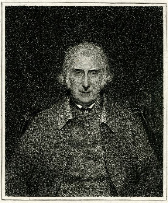
James Brindley engraved by William Holl after William Behnes, c 1820 (BM 1864,1008.17)

William Holl (1771-1838) was an engraver, using stipple (rather than line). He was early in the move from copper to steel engraving plates, which were developed in the USA at the beginning of the 1820s. There are 40 of his engraved ‘LCC portraits’ in the London Metropolitan Archives and around 350 of his prints – a tremendous oeuvre – in the British Museum.  

He was brought up in East London and moved with his family from Stepney to 22 Bayham Street in 1815. (He lived in Charlton Street, Somers Town, by 1822 and thereafter up to his death at Judd Street, Bloomsbury.) Opposite at nos. 2 and 3 Bayham Street were more engravers – Francis Engleheart, who was Holl’s contemporary by age, with his family and also Charles Rolls and Courtney Selous who were younger.

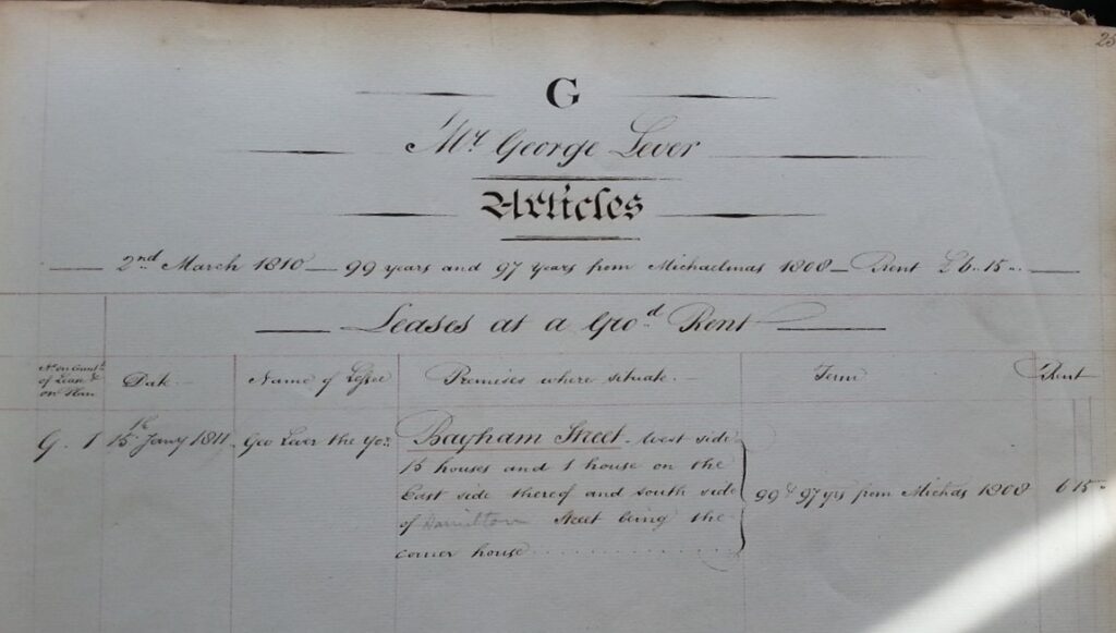
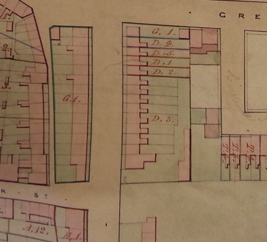
But nearby 16 Bayham Street is known more famously, at this period, as the brief home of ten-year old Charles Dickens. Building leases for the land on the west side, behind the High Street and close to the Mother Red Cap, had been taken out in 1811 by George Lever whose own house, No 1 in the row with his builder’s yard behind, started the numbering going northwards on the east side and returning southwards on the west side.

Camden Town Estate lease book
Camden Town Estate plan 1833. Central is Bayham Street, north end.

There are records for the engravers’ houses in the annual Land Tax and correspondence gives Holl’s number as 22. But precise identification for Dickens is more difficult. His father is not listed in the Land Tax records of 1822 or 1823 on Ancestry (did he indeed pay the tax or was this part of the reason he was sent to debtors’ gaol?). Camden Local Archives Centre came to my rescue, advising that Dickens is the named occupier of 16 Bayham Street in the St Pancras rate books between January 1822 and October 1823, although for the last the property is marked ’empty’  ( – perhaps when the family moved to Gower Street).

Still, which house was no. 16 was not documented at the time. There is a photograph from later in the century for the house that was renumbered 141 (or 161) in the 1860s and there’s a plaque on the red-brick municipal health centre that replaced the housing terrace in the 1930s.

But can we be sure …?

16 (now 161) Bayham Street, Camden, London – home to John Dickens and his family, who moved here from Chatham in 1823. Also the residence of Mr Micawber and this district is referred to in Dombey & Sons as Staggs ‘ Gardens. From a series of cards depicting places connected to the life of the writer Charles Dickens (1 of 6).

www.mediastorehouse.co.uk/p/164/bayham-street-camden-london-dickens-4461183.jpg

St Pancras archaeology and Camden Road conservation

There are proposals for major rebuilding of hospitals around St Pancras, adjacent to Camden Town, and small-scale but significant alterations for the shops of Camden Road broadway.

The Archaeological Assessment for St Pancras includes a photograph of 70 years ago, see above. However, the Assessment is deficient in understanding the Fleet River valley pre-history. Why is this ancient site here? Is ‘St Pancras’ related to Roman or earlier funerary practices? What has happened to the ‘sixth century altar stone’ described by antiquarians? Read this response.

The proposed ten-storey building is criticised by the Victorian Society and Regent’s Network as too high and too dense. We also object.

Also important are two proposals for alterations no 128 and no 126 of the shopping terrace at Camden Broadway which also need arguments for conservation.

Conserve the Brecknock Arms!

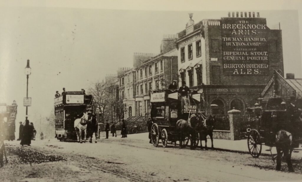
Top of Camden Road looking south around 1900

A call for conservation

Walking up Camden Road to arrive at the new friendly bakery ‘Bread by Bike’ in Brecknock Road (just on the Islington, north side) I passed on the corner the former Brecknock Arms. It’s a grand pub and I’ve known about it since the beginning of this Camden Town work since it marks the further boundary of the estate and the toll-gate at this point was a part of original Act for the new Camden Road in 1824.

Its name got changed a few years ago and there’s been a recording studio in the back. But since March, with covid, it’s looking worse – internally boarded up, and parking for sale in the forecourt.

I’ve written to the Council’s conservation officer to ask for urgent ‘local listing – the available step before Historic England full listing. I received a civil reply, to look and assess. Other voices could help.

Read my document with details.

Cruickshank’s Camden

George Cruikshank was the foremost satirical artist in London in the first half of the nineteenth century, making and selling his own etchings. He lived in his later years, 1850-1878 on Hampstead Road at Mornington Crescent and and Myddleton Terrace, EC1, in 1824-1849. His 1829 print of ‘London Out of Town – the March of Bricks’ shows the River Fleet being ‘invaded’ by brick works.

His father and brother died of alcoholism and in mid-life Cruikshank joined the Temperance Movement. He produced several books, the first of which The Bottle (1847) in eight scenes follows a family’s decline in the same way as Hogarth’s Rake’s Progress. In the third scene, a picture previously seen distantly hanging on the wall has been taken down and is set in the foreground beside a table and a rolled-up carpet. The accompanying verse is:

That picture was a pledge of love and truth / And all were going. Joy was at an end.

From British Library collection

A planning challenge at St Pancras

Rochester Conservation Area’s response to Camden Council’s consultation document ‘Canalside to Camley Street‘.

The Council

  • should protect Camden Town as a conservation area
  • wrongly includes Camden Town development sites
  • lacks attention to the cycle entry points
  • needs to promote walking on the Canal towpath without cycling
  • should promote improvements to use of the railways to benefit Camden Road station as a transport hub;
  • gives little attention to local service provision, particularly GPs and a health centre for east Camden.

There are further significant issues within the site – the excess heights implied (and illustrated in the document); inadequate road connectivity eg with Camden New Town; not fully reflecting Camley Street Neighbourhood Forum Plan’s concerns for food businesses; potential ‘canyon’ effect along the Canal and St Pancras Way.

The consultation document doesn’t recognise the identity and distinctiveness of Camden Town.

And the task of conservation compared with commercial land development is more challenging when the Council is both the land owner and also gains more income the larger the development. The response gives an example of a previous planning application, on Pratt Street / Royal College Street / Georgiana Street / St Pancras Way, with evident conflict of interests.

It has been welcome, therefore, that the Camden conservation committees’ coordinating group and the Council’s planning department are in discussion about the government’s new White Paper on planning. This is a significant moment to extend Camden’s conservation areas to their heritage boundaries.

Regent’s Canal bicentenary

Celebrating 200 years of the Regent’s Canal, which zig-zags below road bridges and over River Fleet. On the north bank was the tow path and building firms used the wharfs along the south side.

On 1st August 1820, an ‘aquatic procession of boats and barges, ornamented with flags and streamers, and filled with ladies and gentlemen’ sailed from Maiden Lane for the opening of the new Regent’s Canal. The Regent’s Canal Company and its chief engineer, James Morgan, had competed ‘a great work, going on for years, upon the whole northern border of the metropolis’  – a waterway joining the Grand Union Canal with a grand new dock at Limehouse, where colliers would avoid ‘the plunder and waste of coal, that so notoriously takes place in the Pool’ (Observer, 25 September 1820). At Camden Town, the canal zig-zagged across the Fleet valley, passing under bridges, built by Richardson and Watts for the four roads (with the fifth, for Camden Road, coming later in the 1820s) and over the Fleet River channelled in a tunnel beneath.

The Canal, its prospectus claimed, would carry ‘Grain, Flour, Vegetables, and all the Necessities and Luxuries of Life’ as well as ‘Flag, Kirb and Paving Stones for the different Streets’ needed for the main business of Camden Town – building. At Pratt’s Wharf, beside Grays Inn Road bridge, was Culverhouse & Co, wharfingers and contractors, with ‘bricks, lime, cement, tiles, slates, sand, pipes, pots, terra cotta…’; Bangor wharf housed William and Josiah Mansbridge brothers, who in the 1860s were building the final northern terraces around Camden Square, while at the end of the century the wharf was used for refuse coming to fuel the St Pancras municipal electricity generator, the Destructor, which was connected by a tunnel with Georgiana Street; at Eagle Wharf there were the forage and provender warehouses and stables of William Brimage; at Devonshire Wharf were, first the Bartlett Brothers, whose enterprising Sanders Trotman promoted potash materials for preservation of stone, and then, with College Wharf, the home for Lawfords’ contractors materials – a company still working locally; M Anderson, and later A and D Anderson, contractors, were at Bayham Wharf; and at the Kentish Town Wharf were, first, William and Edward Wood with coal and then Grover and Grover with timber. 

The Canal tow path was on the north bank, while the wharfs were on the south side and are named in the 1890s Ordnance Survey map.  There is a photographic record of the canal in the Camden archives, the Anthony Cooper bequest, of 1994; yet you can go now, to see and celebrate the original ‘great work’, of canal and bridges which have lasted 200 years.

The Slave Trade and Emancipation Recalled by Streets in Camden Town

Click here for link

I met Maggie Bolton, the history editor for the Transactions of the London and Middlesex Archaeological Society at the Society’s annual meeting, held in at the Museum of London in November last year. I had in my mind a piece about black history in Camden Town, and she encouraged me to get on and write it.

I knew I had material about the Jefferys/Pratts and the Wilmots, and decided to use the street names as the framework. It also became evident that the histories were about the slave trade and about emancipation rather than slavery directly.

The paper was accepted for publication, but the Transactions only comes out once a year, and the expected date is Christmas 2020.  Because of current interest, I’ve put my final version of The Slave Trade and Emancipation Recalled by Streets in Camden Town on this web page.

A digital future

Cover of Rats, Lice and History

The coronavirus epidemic has challenged historical research. Archives and libraries are closed, seminars are by Zoom, books come by mail. Can history tell us anything about the future?

I’ve taken from my shelves a paperback 31st printing (in 1965) of the original 1935 best-seller Rats, Lice and History by Hans Zinsser. He had had a liberal education – the text has words in Greek letters and footnotes in German – but wanted to write for a popular audience. His work as a bacteriologist was elucidating typhus, a bacterial disease transmitted in lice bites which was overcome in the First World War by baths and laundry.

The book describes epidemics over the centuries, which start acutely but can fade into the background, or return to animal hosts, only to resurge as human immunity fades. Our equivalent of baths and laundry is social distancing and isolation – the transmission is not by lice but by coughing and touching.

Our archives and libraries may be able to create distanced settings – I’ve been working during the outbreak as a telephone contact-tracer in an open-plan office, which seems to work if people are careful. The difficulty is people who have the disease symptoms but don’t self-isolate.

We will be ‘back to normal’ in a year’s time, perhaps after a further winter outbreak. In Camden, the ‘normal’ is the local archives, with 200,000 stored items and a programme of talks and exhibitions.  Yet the catalogue is a card-index and the data-records are on fiches and micro-film – inaccessible during the epidemic and indeed to most people most of the time. I wish it were better.

Divide and rule: the new ward boundaries for Camden Town

Every 20 years, the Electoral Wards Commission revises our local ward boundaries. There was a new consultation last year. Changes are needed because of the expanding population: Camden Borough proposes to build 1000 new homes a year (and rebuild others) through until 2030. 

This is the map of Camden Town estate when it was being built in 1850.

Camden Estate map (London Metropolitan Library)

Here are ward boundaries from earlier periods:

In the consultation last year, Rochester Conservation Area recommended two wards, of Camden Town and Cantlowes. Wards are expected to be about 10 000 population, so two were needed – called Cantlowes and Camden Town.

Instead, the Electoral Commission’s proposals, with the Council’s support, will divide Camden Road, with Rochester put into ‘Kentish Town South’; change Cantlowes, the historic name, for ‘Camden Square’; put ‘Camden Town’ at Chalk Farm Road; and call old (south) Camden Town ‘St Pancras & Somers Town’.

Electoral Wards proposed (red) Camden Town estate (blue)

There has been very little interest from local councillors about the changes proposed for central Camden.  Why has Rochester Terrace Gardens been separated from Rochester Square? How will fifteen councillors discuss the needs of Camden Town?

OpenStreetMap